Project implementation: Jamaica
Project development: Germany

Student: Vanessa Verona Herold
Supervision: R. Radulova-Stahmer & V. Katthagen

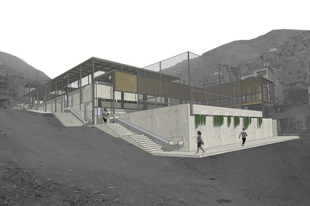
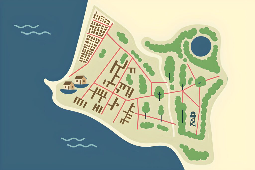
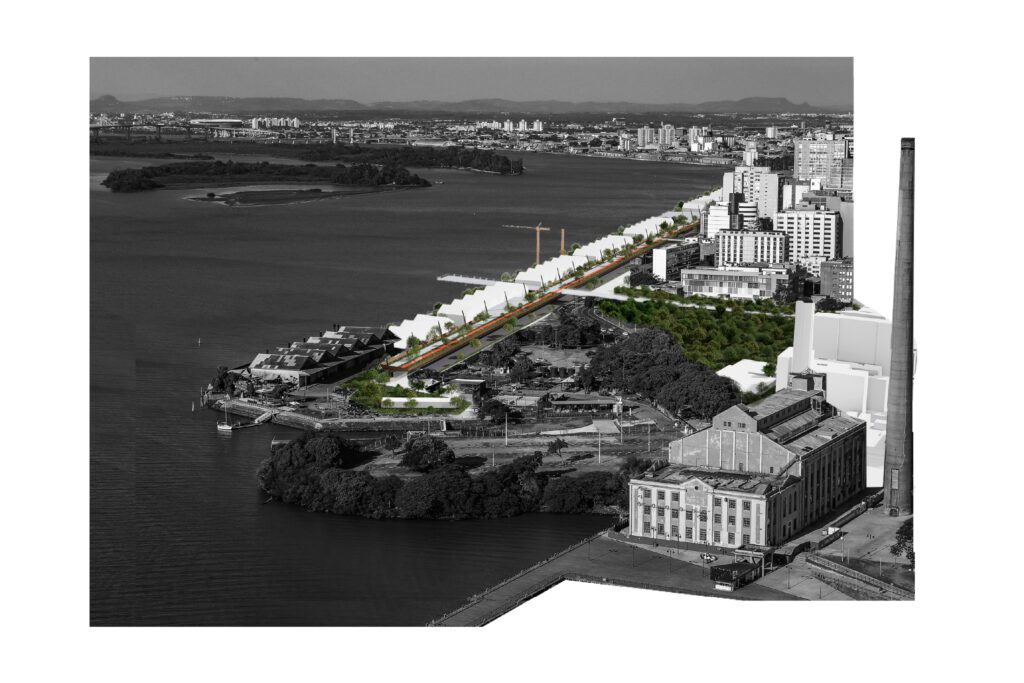
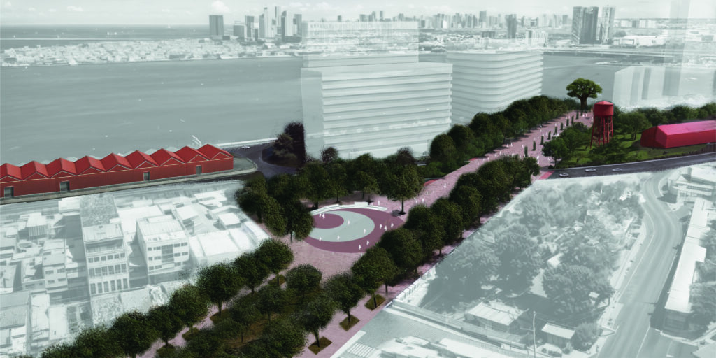
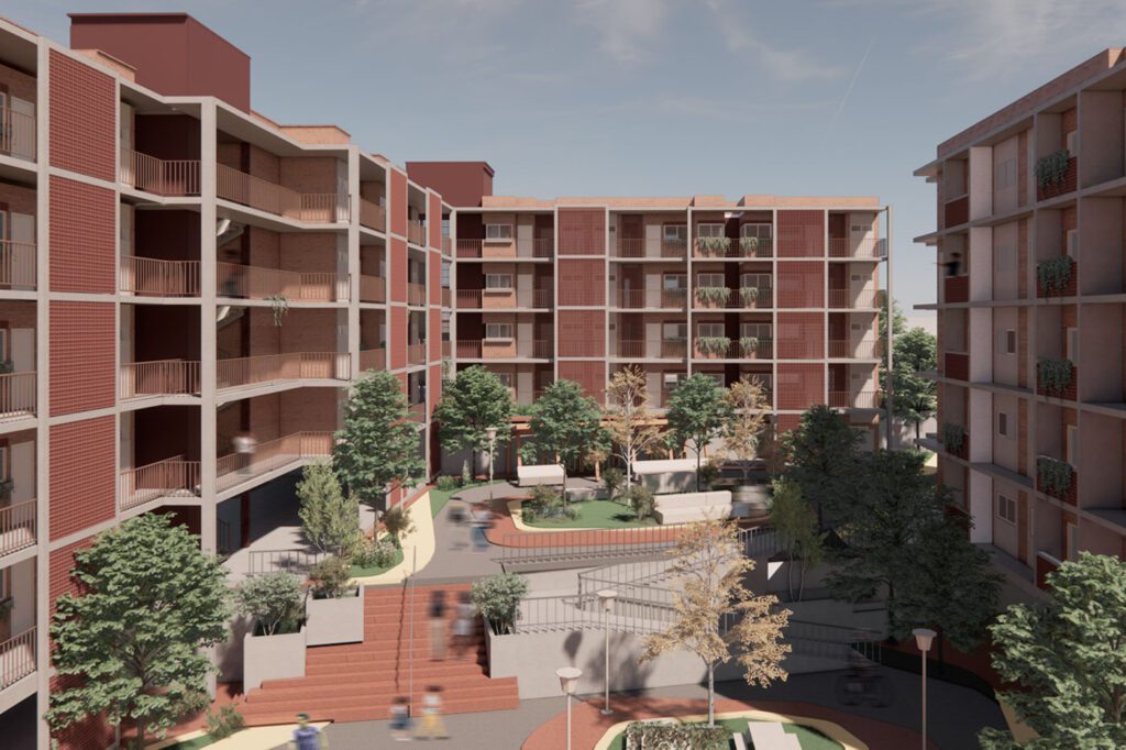
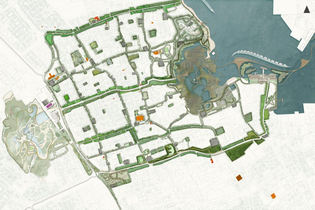
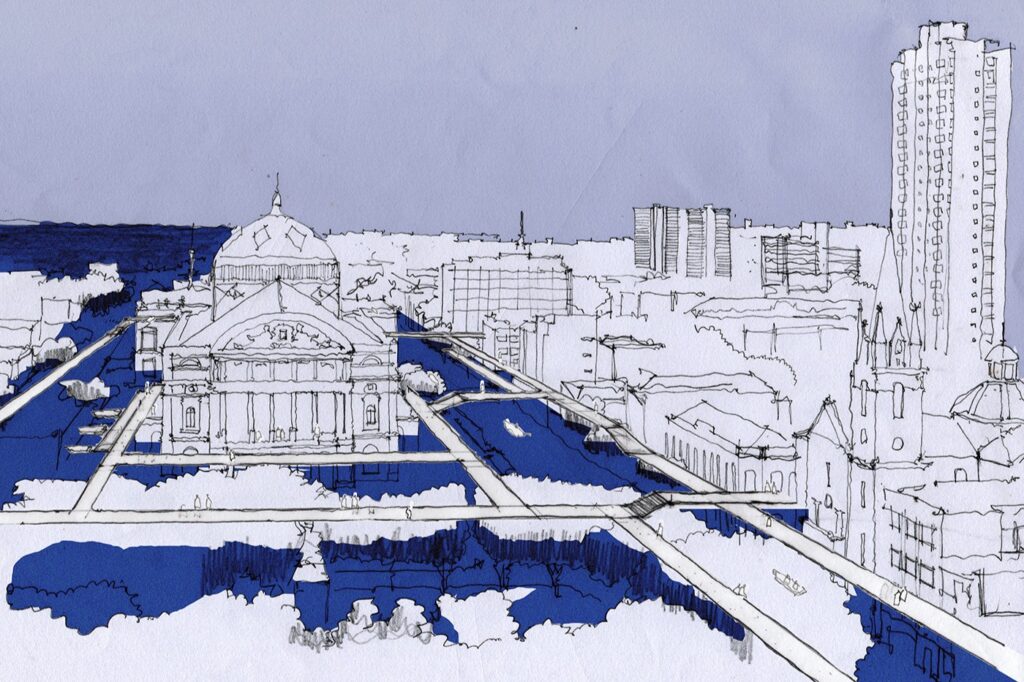
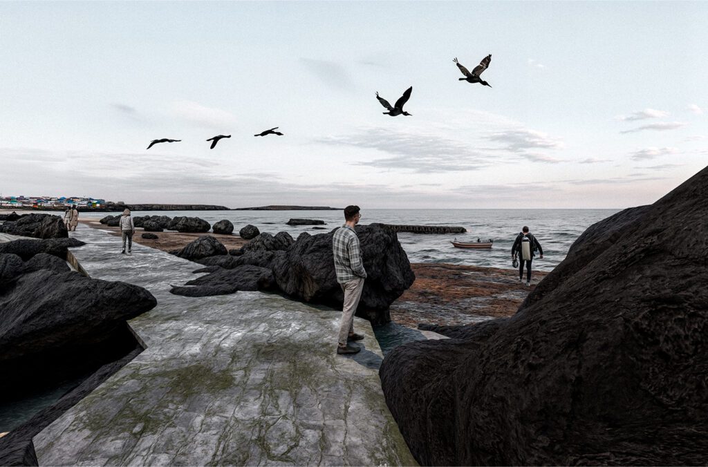
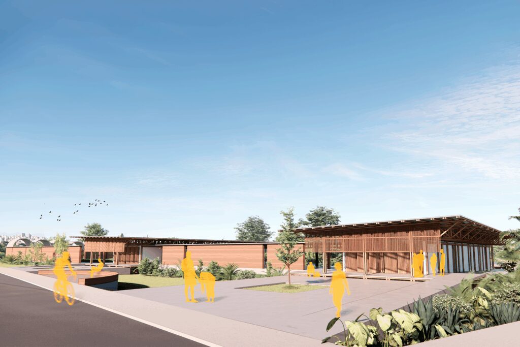
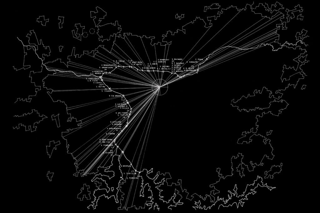
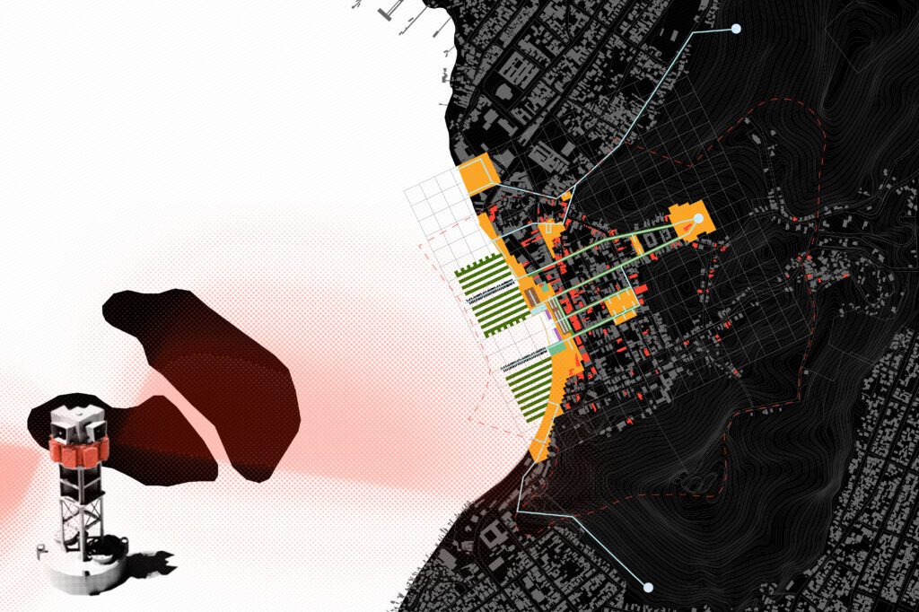
Living Coast – Anchoring Jamaica’s Future is a visionary design proposal dedicated to regenerating and protecting Jamaica’s fragile coastal ecosystems. Conceived as a network of seven rehabilitation stations, the project stretches along the island’s shoreline and addresses diverse habitats: urban waterfronts, mangroves, brackish water zones, seagrass beds and coral reefs, deep-sea environments, and sandy and rocky shores. Each station acts as an anchor point, strategically designed to meet the challenges of its specific environment while contributing to a larger, interconnected system of recovery.

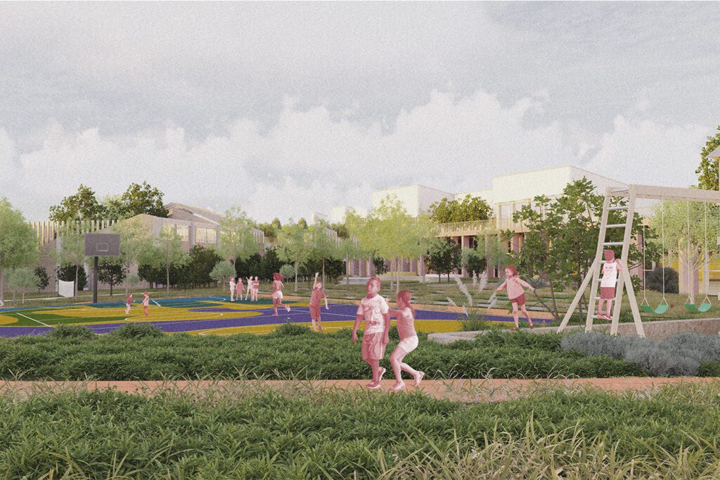
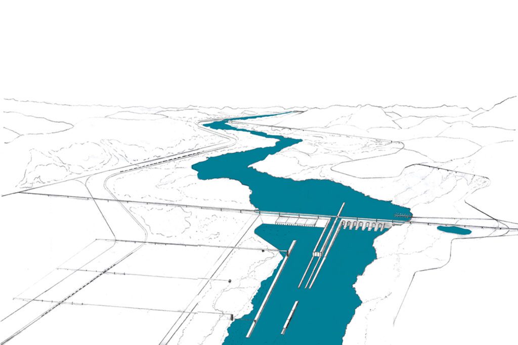
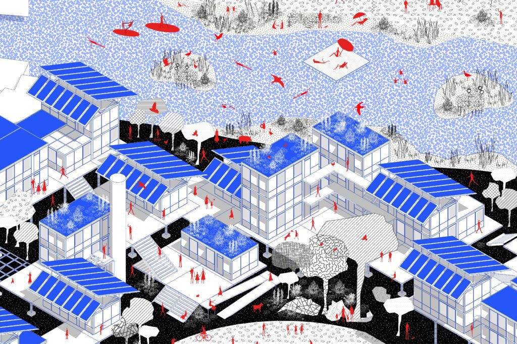
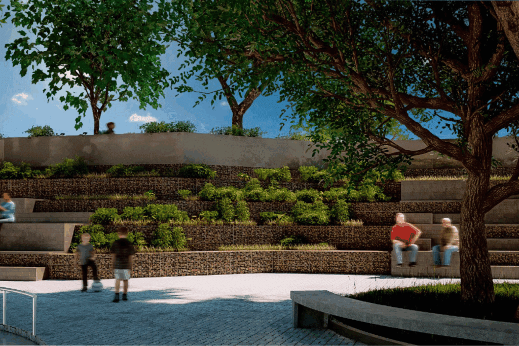
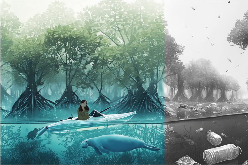
The interventions unite climate adaptation, ecosystem restoration, and community engagement. Floating wetlands filter water and create habitats for aquatic species; bio-active wave breakers protect coastlines while hosting marine biodiversity; mangrove and coral nurseries cultivate life for reintroduction into degraded areas. Animal rescue pools, ecological bridges, and microfilter kayaks illustrate how nature-based strategies can merge with architecture and landscape design. These examples are part of a wider vision: taken together, the seven stations form a holistic, transferable framework that strengthens resilience and redefines how humans interact with coastal landscapes.

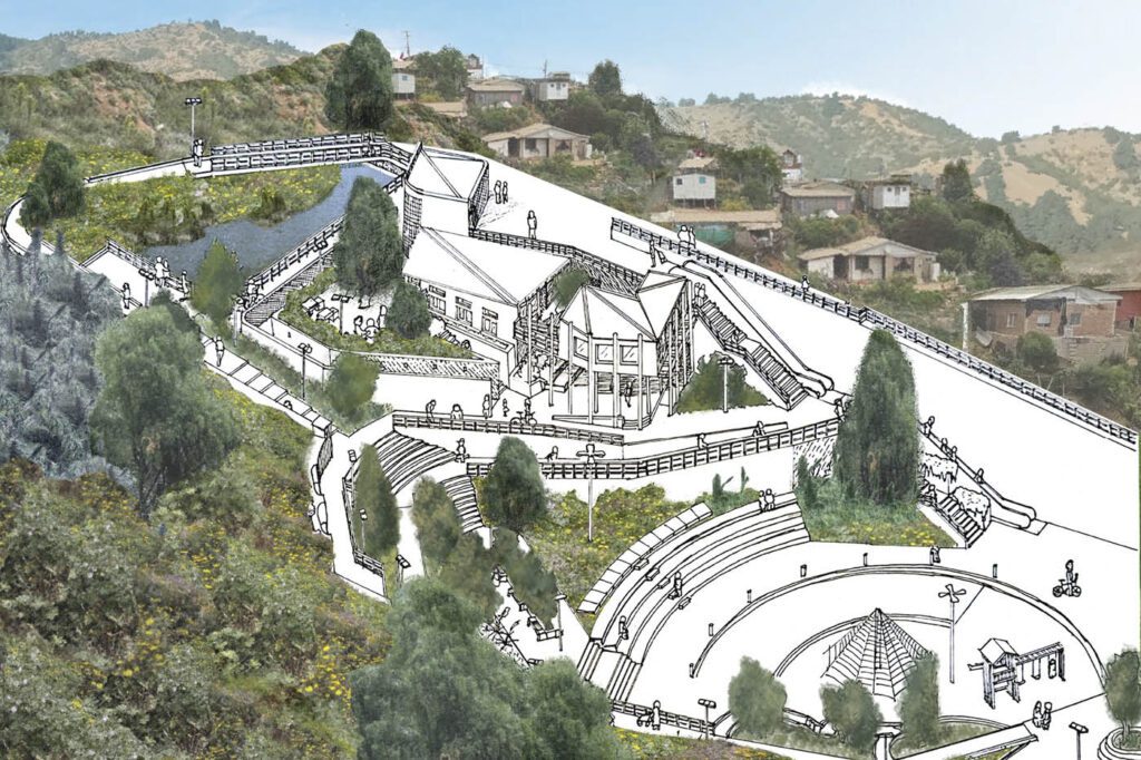
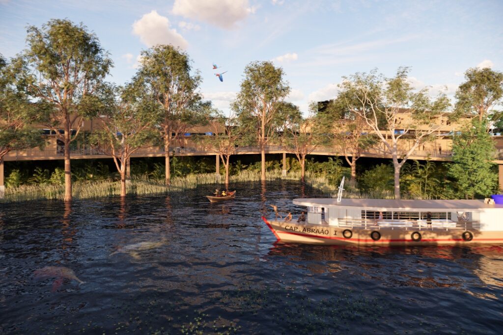
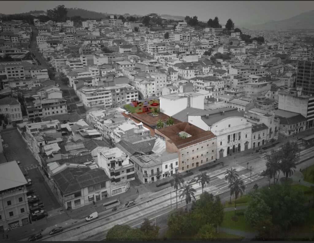
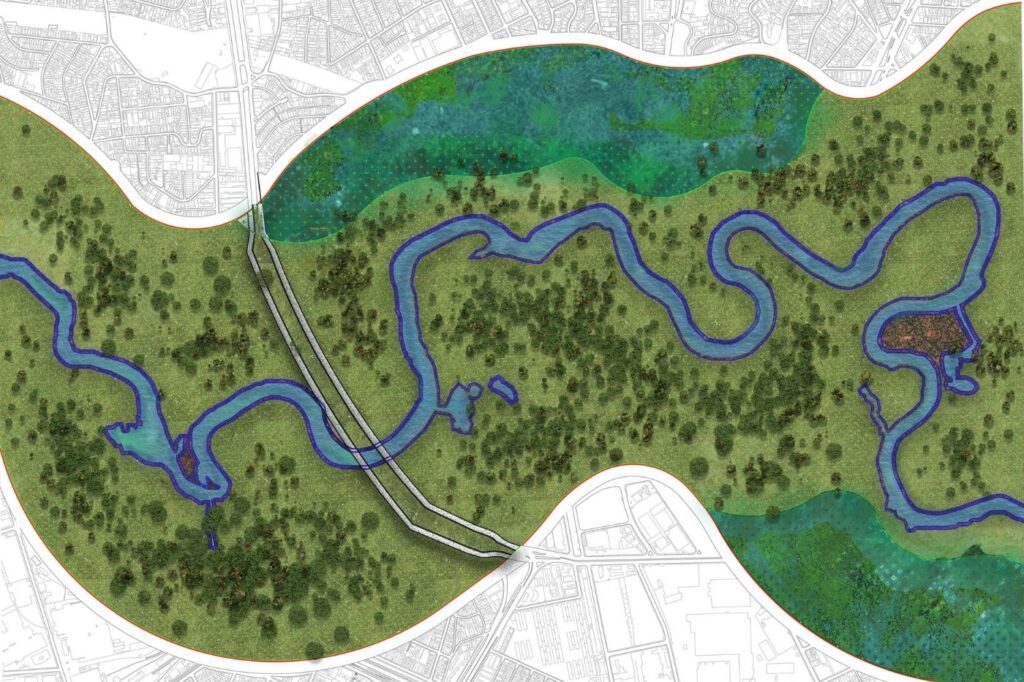
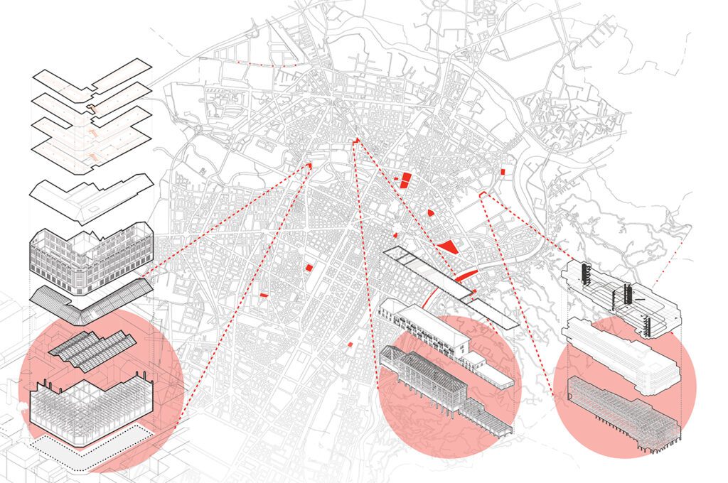
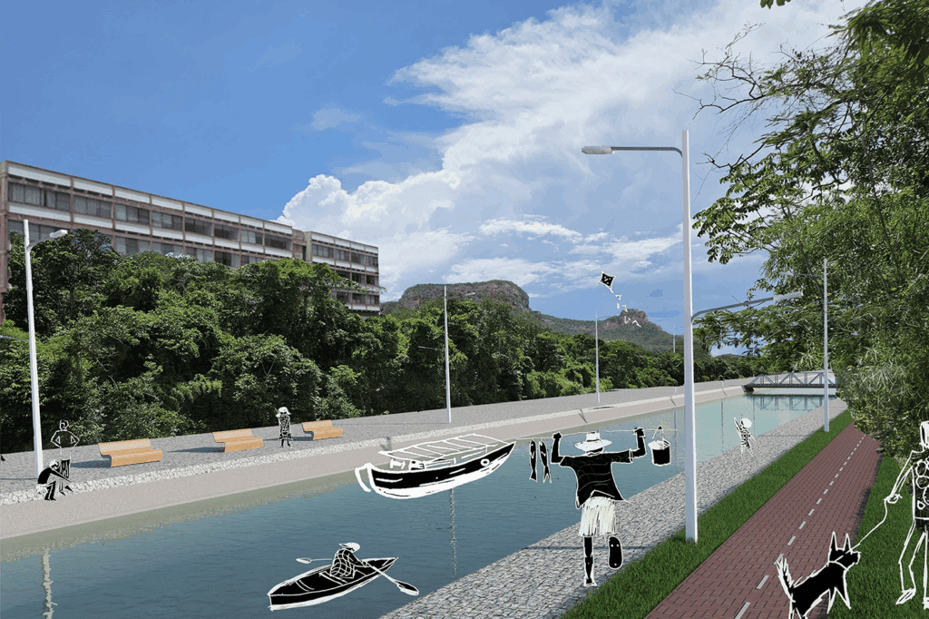
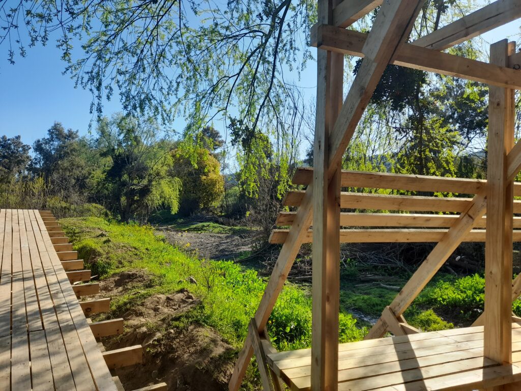
While all stations were conceptually explored, three were studied in greater depth to exemplify the strategic approach: the Mangrove Station in Jackson Bay, where nurseries and stilted walkways restore a vital carbon sink; the Sandy and Rocky Shoreline Station in Unity Bay, where the coast and sea turtles are protected through bio-active defenses and a rescue center; and the Estuary Station in Buff Bay, where ecological bridges and water delay pools revitalize fragile river mouths. Together, they demonstrate how locally tailored strategies become part of one living system.

Behind this project stands Vanessa Verona Herold, a German-Jamaican Master’s student of Architecture at the Jade University of Applied Sciences in Oldenburg, Germany. After completing her Bachelor’s degree with distinction, she is currently finalizing her Master’s thesis with outstanding results. Her earlier studies in Art, Media, Philosophy, and Ethics have shaped a creative yet reflective design approach, balancing artistic imagination with a deep sense of ecological responsibility. With a focus on public cultural buildings and urban design, she consistently integrates social and environmental dimensions into her work.

The project was developed within the Master’s course “Individual Design Project” under the guidance of Prof. Dr.-Ing. Radostina Radulova-Stahmer (Regenerative Urban Design) and Prof. Dipl.-Ing. M.Sc. Volker Katthagen (Urban Design and Landscape Planning). Both encouraged her to explore the intersection of architecture, ecology, and community, while she independently conceived and developed the concept.

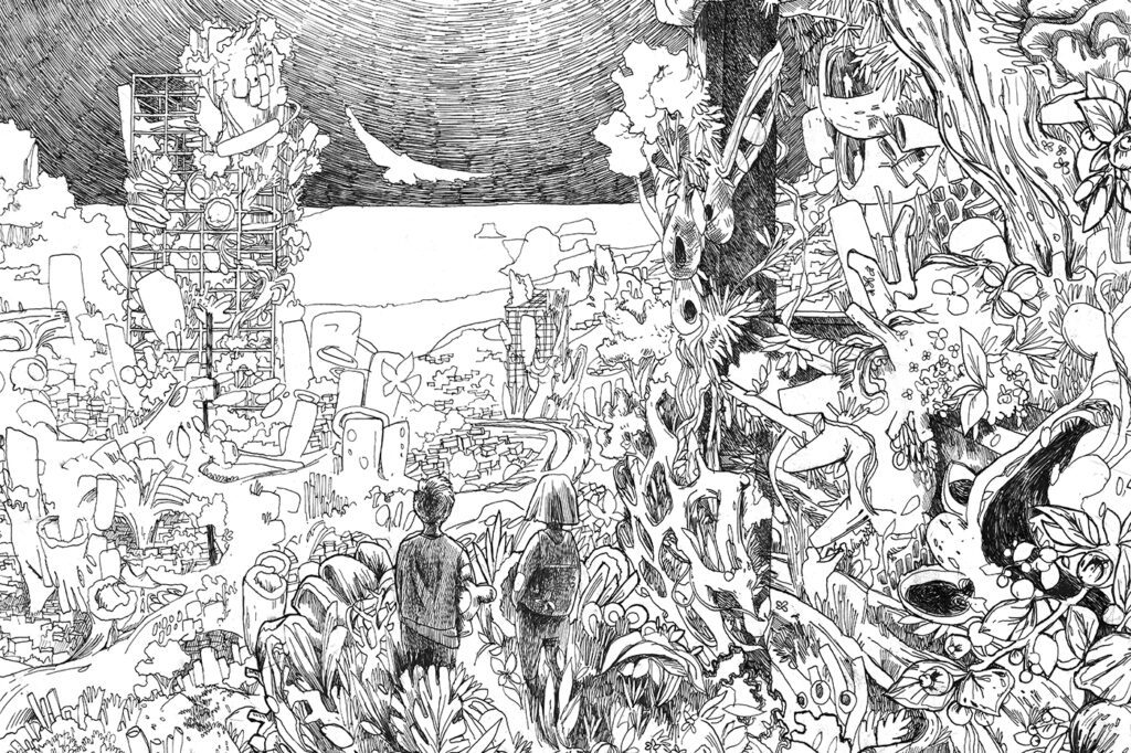
For Herold, Living Coast is more than an academic exercise — it is a personal vision deeply connected to her Jamaican heritage and her conviction that sustainability in architecture must extend beyond human-centered design. “Sustainability,” she emphasizes, “is not optional. It is a fundamental responsibility — to future generations, to the past we honor, and to the ecosystems we depend on.”

By anchoring ecological recovery along Jamaica’s shores, Living Coast offers not only a hopeful blueprint for biodiversity conservation and climate resilience but also a scalable strategy for coastal regions worldwide — a promise to safeguard the island’s natural wealth and inspire sustainable futures for generations to come.

Students: Ishiyama, Condori, Fuentes, Meneses, Paucar, Quispe

Lima is located in one of the few desert valleys on the Peruvian coast and is a major draw for migrants seeking opportunities. The city grew haphazardly, receiving residents from the interior who settled precariously, often in vulnerable and unsuitable locations.
San Juan de Lurigancho (SJL) is the district with the largest population in Lima and is a clear reflection of the city's overflow phenomenon.


“San Fernando” is located in sector 4 of SJL, and is formed by a group of young communities that share a school, businesses and a single public space.

The public space consists of three platforms arranged in a descending order. The lower platform is the volleyball court, the middle platform is the multipurpose slab, and the small upper platform is the games area. The project proposes reusing the site's infrastructure, making small improvements to enhance existing activities and promote new ones through the use of flexible space.

The sun's path is studied to expand shaded areas and take advantage of natural ventilation. Energy is generated for equipment and lighting using solar panels, treated graywater is reused to enable hydraulic mechanisms to assist people with disabilities and maintain a community green space.

The installation of a water storage reservoir and a gravity distribution system is proposed to guarantee access to the resource in periods of drought, emergency or disaster.

The project seeks to improve the sector by doing a lot with a little. We hope that the neighborhood will find adequate support in improved public spaces to gather, organize, and face challenges.

Project implementation: Brazil
Project development: USA

Student: Rodrigo Gallardo

The Fluid Territory explores the city beyond maps, the one that exists in the memory, experience, and untold stories of its inhabitants. In Vargem Grande, on the outskirts of São Paulo, this difference becomes evident: maps show it as an urban fragment amidst the forest, but daily life reveals another reality, marked by precarious housing, a lack of support in schools, and a territory lived between fear and oblivion of nature.

The project emerged from dialogue with residents and the presence of the Guarani, recognizing that the territory is shared between different worlds: the Jurua, who arrived in search of housing, and the indigenous people, whose worldview offers other ways of living. Rather than imposing closed responses, the interventions propose open conditions capable of accommodating the diversity of voices and needs.

At school, narrow corridors and hot metal rooms give way to meeting spaces where knowledge circulates beyond the walls. In homes, what was once instability is transformed into structures that strengthen the permanence and dignity of their residents. The forest, once feared and distant, is reconnected by trails and paths that invite use, coexistence, and collective memory.

The work doesn't seek definitive solutions, but rather to open up possibilities. It's about thinking of architecture as a listening tool, capable of bringing to light what already exists latently: the strength of community, shared memory, and the coexistence of different ways of life. If every city is a palimpsest of overlapping histories, here the architectural gesture is not to erase, but to reveal.

More than constructing buildings, it is about creating conditions so that new paths can be opened, paths in which the school, the home and the forest cease to be isolated fragments and become part of the same collective fabric.

Project implementation: Brazil
Project development: Brazil

Department of Architecture and Urbanism – UFES. Special Projects II (ARQ 12226). 2025/01

This proposal is a partial result of the Special Projects II course (ARQ-12226) offered by the Department of Architecture and Urbanism at the Federal University of Espírito Santo (DAU-UFES). It is a continuation of academic studies and research by faculty and students that relate water to cities. The approach is that of architectural design for urban and regional river and maritime infrastructures, seeking to address the fundamentals of multiple water uses and the comprehensive utilization of river basins. The main object of study is the Doce River—an important basin in the Southeast Hydrographic Region—which has its contribution area in the states of Minas Gerais and Espírito Santo.

Historically, the Doce River valley was a route for penetration into the continent—as a natural waterway, its navigation was carried out along waterways, complemented by land routes along its banks. Successive human actions devastated the riverbanks, eliminating riparian forests and silting up the riverbed. This culminated in 2015 with the collapse of the Fundão dam in Mariana, Minas Gerais. This released mining waste into water bodies, contaminating the Doce River basin on a monumental scale. From Minas Gerais to Espírito Santo, a torrent of toxic mud reached Brazilian territorial waters, with impacts that are still being measured.

The proposed Rio Doce waterway encompasses the middle and lower reaches of the river, between Ipatinga (MG) and Regência (ES), connecting the Vale do Aço region to the seaports as a third transportation hub that connects to the Vitória-Minas Railway (EFVM) and the highways along the river's longitudinal slopes. The proposed main waterway is 444 km long and has a total water drop of 215 m from Ipatinga to the mouth. It features 35 Multiple Use Dams (MBDs)—32 new low-head dams and three existing dams spanned by lock ladders. The new dams—with maximum drop heights of 5 m—were designed to adapt to the urban and environmental scale of their surroundings, minimizing flooded areas along the banks and reducing the risk classification of the dams. In addition to navigation, the dams integrate functions such as low-cost power generation, environmental sanitation, riverbank connections, aquaculture/fishing, flood control, and drought relief. The main reservoirs will be complemented by feeder lakes on the tributaries, constituting an integrated infrastructure system for regulating year-round flow and recharging the basin's water resources. The flooded areas can also be used for public sustainable water use programs in positive partnerships with riverside communities. The waterway also opens up opportunities for environmental education, recreation, sports, and river tourism along the reforested banks, improving the coexistence of riverside communities.

Project implementation: Italy
Project development: Italy

Students of the Learning from Abroad 2025 course: Andrea Moscatelli, Carmen Cicia, Chiara Di Cesare, Enrico Maria Corvese Ester Teresa Castillo Anis, Flavia Montegiglio, Francesco Di Gennaro, Gabriele Petrucco, Gianmarco Ottaviani, Hanna Helm, Leonardo Brustolon, Nina Signolet and Valentina Martucci

We are experiencing an unprecedented climate crisis. Despite the 2015 Paris Agreement, the world has failed to reduce its emissions. The year 2023 broke records, and 2024 confirms an even more alarming trend. Climatologists admit their predictions were optimistic: the 1.5°C limit, predicted for 2030, has already been surpassed. The relationship between carbon emissions, rising temperatures, and rising oceans is now indisputable.

In this critical context, the Learning from Abroad course at Roma Tre University proposes an urgent design reflection, recognizing the challenges of this generation of architects, called to work in a scenario of uncertainty and accelerated change. The project L'Architettura Inevitabile confronts the unpredictable: we don't know what the future sea level will be, nor the impact on production chains, infrastructure, and climate migration, with territorial impacts on a planetary scale.

Some cities will have the resources to contain the sea, but not most. It's time to abandon the idea of dominating nature: water is stronger and older than we are. We must learn to live with it and reinterpret territories intelligently.

The students worked on the topic based on a specific case, the Isola Sacra, on the Roman coast. They assumed a 2-meter sea level rise scenario—extreme, but increasingly plausible. Together, they studied the history and characteristics of the site. Then, organized into subgroups, they developed integrated architectural projects, without losing sight of collective decisions. The regional, local, and architectural scales worked together—as they should.

This work presents a collective masterplan composed of five distinct yet closely integrated projects. Each one confronts the water in a unique way: a cultural center that transforms with the tides; a hospital on stilts; floating houses and a school that rise with the water; a sports center that integrates the water as a landscape; and an archaeological complex that incorporates the transformation of the territory into its discourse.

In all of them, time and water are the protagonists.

Finally, one final project remains in the embryonic stage for future reflection: the archaeological park of the future. A denser area of Isola Sacra, which will be overtaken by water and vegetation, will be transformed into a visitable ruin, a monument to our time and the contradictions of territorial occupation.
It's worth remembering: this is a highly complex, short-term project, from the territory to the building. Neither the Masterplan nor the projects are intended to be final. Even without the time, depth, and interdisciplinarity that the topic demands, the students embarked on a painful but urgent challenge. The project by students Andrea Moscatelli, Carmen Cicia, Chiara Di Cesare, Enrico Maria Corvese, Ester Teresa Castillo Anis, Flavia Montegiglio, Francesco Di Gennaro, Gabriele Petrucco, Gianmarco Ottaviani, Hanna Helm, Leonardo Brustolon, Nina Signolet, and Valentina Martucci can be understood in greater detail here: https://acesse.one/tQjaH

Project implementation: Brazil
Project development: Brazil

Students: Caroline Jahn, Fabiane Calistro, Guilherme Staub, Yan Kruchin

Between Margins: A City in Layers is a project that seeks to reconcile Porto Alegre with Lake Guaíba, redefining one of its greatest symbols of separation: the Mauá Wall. Porto Alegre has always been shaped by its relationship with water—a presence that, over time, has become both an identity and a challenge. Once a space for gathering and leisure, Guaíba is now also a physical and symbolic boundary, marked by floods that expose the vulnerability of urban infrastructure to climate change.

Built as a barrier against flooding, the wall ended up separating the city from its shoreline, transforming contact with water into an absence. By trying to contain the river, the city contained itself, relegating the lake to an inaccessible backdrop. The proposal recognizes this rupture and seeks to transform it into an opportunity: it reconfigures the wall not as a barrier, but as a seam between the natural and the constructed, between past and future.

The project redesigns this rigid border as a space for gathering, circulation, and permanence. An elevated promenade connects the Historic Center to Cais Mauá, restoring pedestrian prominence and offering spaces for leisure, contemplation, and active mobility. Green strips and bike paths run along the route, aiding urban drainage and providing environmental comfort, while the pier's warehouses are reactivated as cultural, gastronomic, and community hubs.

Its materiality reinforces these principles: a lightweight and sustainable structure, made of engineered wood and prefabricated modules, with green infrastructure solutions – such as rain gardens, permeable pavements, and native vegetation – increasing urban resilience in the face of extreme events.

Entre Margens doesn't erase history: it recognizes the city's layers, its boundaries, and contradictions. The Mauá Wall remains—but now, it's ground. It's a path. It's a city.

Project implementation: Chile
Project development: Chile

The action-research project "Errando se Aprende" (Errando se Aprende) is located in Reñaca Alto Sur (Viña del Mar, Chile), a region marked by housing insecurity, urban exclusion, and vulnerability to wildfires. The Huasco ravine, historically seen as a boundary, has great potential to become a corridor for community and ecological life. The climate crisis and the 2024 fires have heightened the urgency of rethinking this space, highlighting the need for infrastructure capable of protecting the population and ecosystem.

In this context, a collective masterplan was developed, built through participatory workshops, tours, and community observations. The strategy views the favela as an inter-neighborhood park, connecting villages through green infrastructure, community facilities, and fire protection corridors. More than simply designing spaces, the goal was to shift perspectives: understanding the encampment not just as an informal settlement, but as a territory with a right to the city and a sustainable future.

Based on this, a Community Meeting Center was proposed at a strategic location in the favela. The building connects the inter-neighborhood park to everyday spaces—a cafeteria, playroom, and offices. It's not a standalone facility, but the embodiment of the masterplan as a space for gathering, cohesion, and mutual care, capable of strengthening community networks.

The project also introduces a new type of water reservoirs, designed as a prototype for community infrastructure. They serve a dual purpose: storing gray water for daily use and forming a fire protection network in areas where fire is a constant threat. This creates a new field of basic infrastructure for camps, combining safety, sustainability, and community care.

The choice of masonry responds to technical and social criteria. In a territory with difficult access and high exposure to fire, brick ensures resistance, permanence, and community ownership through self-management in construction. Materiality is also a pedagogical resource for learning and collective rooting.

The project demonstrates that architecture, beyond shelter, can activate processes of resilience and territorial justice. The favela, historically neglected, becomes the hub of a situated urbanism that connects nature, community, and the city. Even in contexts of extreme precariousness, it is possible to design infrastructures that are not palliatives, but triggers for social and environmental transformation.

More than an academic exercise, this is a research-action process that connects urban and architectural scales, moving from a collective masterplan to concrete community infrastructure. This process reveals the project's purpose: not to impose external design, but to collectively construct responses that combine heritage memory, shared care, and new ways of living in times of climate crisis.

Project implementation: Brazil
Project development: Brazil

Student: Victoria Emanuelle Belo da Silva

The development of affordable housing in the Amazon often ignores the region's environmental and cultural peculiarities, adopting standardized, fragile solutions disconnected from the riverside lifestyle. The Casario project emerges as an alternative, proposing an architecture that combines technical innovation, local identity, and ecological respect, focused on decent housing and territorial regeneration.

The design is inspired by riverside houses and stilt houses, reinterpreting these typologies according to contemporary criteria. Certified wood structures combined with concrete pillars ensure strength, durability, and natural ventilation. Passive strategies, such as solar orientation, shading between volumes, and ventilated roofs, promote thermal comfort and energy efficiency without relying on artificial systems.

Located in a Special Area of Social Interest (AEIS) on Avenida Brasil in Manaus, the complex integrates green spaces, community amenities, and collective spaces, strengthening coexistence, belonging, and solidarity networks. Two-story semi-detached blocks feature a variety of typologies, taking advantage of the prevailing ventilation and creating air corridors that function as cooling tunnels, improving indoor and outdoor microclimates.

In the environmental sphere, the proposal works to restore urban streams through natural drainage, artificial wetlands, and biological filters, transforming degraded areas into ecological corridors that connect the natural environment to the city. Thus, inhabitation also means restoring ecosystems, respecting water cycles and traditional ways of life.

Community participation is crucial. The use of regional timber enables assisted self-construction, maintains local techniques, and strengthens ties with the region. Public, private, and housing cooperative partnerships increase economic and social viability, promoting inclusion, autonomy, and local leadership.

Casario demonstrates that social housing, environmental restoration, and cultural appreciation can coexist. By harmonizing vernacular knowledge, modern construction solutions, and ecological care, the project redefines the relationship between city, nature, and society, offering a model of sensitive and sustainable urbanism in the urban Amazon.

Victoria Emanuelle Belo da Silva, a native of Manaus, develops projects that combine environmental preservation and architectural innovation. Her practice emphasizes the restoration of degraded territories and the promotion of local knowledge, contributing to more just and sustainable Amazonian cities.

Project implementation: Ecuador
Project development: Ecuador

Students: Teresa Godoy Lema (Fondo Jubilados DMQ-N), José Martí-Paula S. Mendoza G (Pasaje)

N. Teresa Godoy Lema.
Alumni of the Pontifical Catholic University of Ecuador, originally from El Ángel – Carchi. My passion lies in heritage rehabilitation and in designing spaces that go beyond the physical: I seek to create places that strengthen collective memory and nurture community life. For me, architecture is a living bridge between what we were and what we want to be, a tool to keep our identity alive and inspire new ways of inhabiting the city.

Intermediate Spaces for Memory: Comprehensive Rehabilitation of the Retirement Fund–DMQ.
Architecture, beyond offering refuge, can create spaces that foster interaction and preserve collective memory. This project proposes a Wellness and Memory Center focused on the elderly, recognizing their role as guardians of cultural memory. The importance of connecting these adults with children was identified, ensuring that their stories and knowledge are passed on to future generations. Thus, the design proposes spaces that strengthen the connection between past and future, with recreational and community activities that promote the mental, physical, and psychological well-being of both groups.

Paula S. Mendoza Gómez
An alumni of the Pontifical Catholic University of Ecuador, she is an architect passionate about architecture's ability to transform people's lives. I conceive of design as a tool for creating spaces that improve not only physical quality of life, but also mental and emotional quality, fostering well-being, social connection, and a harmonious relationship with the environment. I strive for each project to connect with the community and its context, fostering places for meeting, rest, and coexistence. Architecture is not only construction, but also memory, care, and an opportunity for change.

Housing and community services in Paseo José Martí-DMQ.
This project proposes the rehabilitation of the José Martí promenade as a precursor to an identifiable neighborhood, recognizing that the hotel monopoly has driven out the area's residential function, transforming the Historic Center into a lifeless passageway. The critical need was identified to recover the republican courtyard house typology as an active social structure, applying theories of historical restoration that balance heritage conservation with contemporary livability. Thus, the project proposes housing and community services that transform the promenade into the backbone of a new community, leveraging the increased ridership of the La Alameda Metro to create permanent spaces where multigenerational families can symbolically appropriate the space, establishing a replicable model of repopulation that counters the depopulation trend of the Historic Center.

Project implementation: Brazil
Project development: Brazil

Students: Aline Saemi Nakamura, Camila Miwa, Livia Naomi Nishijima Yohei, Luisa Caminha de Figueiredo

Developed by four architecture students from different Brazilian states, the project investigates the role of architecture in territories that have faced the most extreme effects of inequality and environmental crisis for decades. These are communities that are invisible, racialized, and pushed to the edges of cities and public policies. Places where the soil gives way and floods, and where water is not a cycle, but a constant threat.

In the East Zone of São Paulo, in the Jardim Lapena neighborhood of the São Miguel Paulista district, this reality materializes. The occupation began in the 1950s and today is home to approximately 12,000 residents. It is within this context that the project "Links: Between Margins, Cycles, and Belonging" fits in, a proposal that seeks to reestablish essential relationships between territory, nature, and community. The project recognizes people and nature, values the processes that keep life moving, and reinforces the sense of belonging of those who already live there.

The proposal is based on a versatile and replicable structure, tailored to local needs. It offers essential infrastructure to address flooding, lack of drainage, and lack of safe spaces, and creates support for community and regenerative relationships. It recognizes the value of existing initiatives but acts in a complementary manner, expanding the resilience and prosperity of these communities.

The strategy utilizes a careful analysis of the territory and the concept of urban acupuncture as a sensitive and immediate action. Underutilized vacant spaces—within a 50-meter radius—were selected for the implementation of the first units, responding to needs identified through dialogue with residents: bathrooms, kitchens, shelter, and security.

More than offering physical protection, the project proposes a new form of presence: firm yet respectful. It affirms the importance of those who already live and resist, offering support so that these lives can be restructured with dignity. By raising the platforms off the ground, it also creates space for nature to return and regenerate, reestablishing more caring relationships between body, territory, and environment.

Because yes, architecture can and should be a tool for social justice. But to do so, we must recognize that, for too long, it has been complicit in processes of exclusion, removal, and silencing. The challenge is not just to design, but to restore connections, give visibility, and structure the permanence of those who, for decades, have been silenced.

Project implementation: Brazil
Project development: Brazil

Team of students from the Armando Alvares Penteado University Center (FAAP) 

Reclaiming the rivers and living with the waters: healing the city of São Paulo is a project that begins with recognizing the city's origins. São Paulo was born from the rivers—Tamanduateí, Anhangabaú, and Tietê—which structured the initial settlement and were places of meeting, shelter, and exchange. With modernization, urban logic imposed itself against nature. Prestes Maia's Avenue Plan, in the 1930s, corroborated this separation by channeling waterways, waterproofing banks, and transforming rivers into drainage channels, invisible beneath the asphalt. The result is a city that today experiences the effects of its denial: recurring floods, heat islands, and environmental collapse. Our proposal stems from a radical gesture: tearing apart the city to return space to the rivers. This image is not only poetic, but strategic. It is not about returning to the past, but about recovering forgotten wisdom: nature is not an obstacle, but a path. Reclaiming water is the antidote to a "development" model that insists on suffocating the territory. The project is anchored in three symbolic and complementary locations, which serve as replicable examples for the entire metropolis: Morro Grande Park, Água Preta Stream, and the Tietê River. In these locations, we propose restoring the natural course of rivers and streams, allowing them to flow freely again. Their banks become zones of protection and coexistence, with the expansion of Permanent Preservation Areas (APPs) proportional to flood risk studies. This strategy transforms linear parks into living urban drainage systems, functioning as wetlands capable of reversing floods while simultaneously providing quality public spaces. Green infrastructure is essential. Native species rebuild riparian forests, filter water, and ensure ecological balance. Green corridors connect different areas of the city, promoting biodiversity and shade in a territory marked by excessive concrete. Thus, drainage, leisure, environmental health, and cultural memory converge in a single space. Our project stems from this collective desire: to reimagine São Paulo through its waters. By giving voice to the rivers, we give the city its breath. It's an invitation to envision a metropolis where infrastructure and ecosystem are not opposites, but allies. Tearing up the asphalt, letting the water flow, and opening greenways is more than a utopian gesture: it's a survival strategy for a hot world.

Project development: Russia

 TIArch Studio Students

TIArch is an educational Studio of conceptual design, based on the authentic methodology of teaching architectural disciplines by Ilnar Akhtiamov. Since 2009, it has been operating on the basis of Kazan State University of Architecture and Engineering. As part of these research fields, the Studio develops topics, related to urban space perception, city structure, urban communities, implementation of modern technologies and bio-technologies in architecture, and much more.

All research topics, deal with today’s context and have vision for the future, including the one presented here.
"We are responsible for what our predecessors built."
There are countless abandoned, vacant, decaying buildings all over the world, inherited from previous generations. In tangible or intangible form, such architecture, being a parasite on the body of the city, creates a “toxic” field around itself. It marginalizes neighborhoods, creates problems or complements existing ones. Today, this legacy forms a serious challenge for architects and requires a special constructed optics to solve the accumulated problems.

What if we use these locations in the city as an opportunity to experiment? The objects are already deteriorated in their own way - this gives us freedom of action, the lack of fear of making things worse leads to bold and radical solutions. As a result, objects can change a lot, change function, scale, and sometimes even users. But most importantly, the facilities are given the opportunity to change and work for the benefit of the individual.

We are heirs to the modernist solutions of demiurgic architects, whose first step (for future mistakes) was to tear down the past. Within the framework of the proposed solutions, we leave the demolition of the building as the worst possible development of the object, the actions performed on it. And not because the object ceases to exist, but because something more monstrous and destructive can arise in its place. Our approach is based on other methods - local and subtle solutions to work with the existing architecture without demolishing the object, no matter how malignant it may seem to the city. When working on a building, we use exploratory and unrefined solutions that are not a demonstration of the architect’s ambitions, but become a saving manipulation for the object.

The time for inaction is over — the moment has come to see the abandoned and forgotten corners of our cities not as burdens, but as spaces of possibility, experimentation, and new forms of life. The Babylon Project calls not only on architects and urbanists, but above all on local communities, artists, activists, and all those who feel responsible for the future of their cities to step beyond conventional solutions and stop waiting for change to come from above. It is through courage, grassroots engagement, and collective action that we can breathe new life into what once seemed lost.

«We are responsible for what our successors inherit»

Project implementation: Brazil
Project development: Brazil

The project "City of Popular Cultures: Insurgent Crossroads" is an outreach initiative that proposes the urban and ecological redefinition of the São José neighborhood in Recife, Pernambuco. Developed by students and professors from the Architecture and Urban Planning program at the Catholic University of Pernambuco, the study responds to a demand from the Popular Culture League, made up of teachers, performers, and artists who mobilized to demand a permanent space to keep their traditions and cultural activities alive in the city.

Adopting a decolonial and participatory approach, the project uses local ancestry as a structuring axis to build an architecture focused on urban resilience and climate justice. Its methodology is based on active listening and ongoing dialogue with the community, whose experiences and expectations guided every stage of the work.

The architectural intervention envisages the adaptive reuse of decommissioned railway warehouses, converting them into multifunctional centers with a museum, a gastronomic hub, a training center for traditional knowledge, and spaces for making ornaments. The design of these spaces follows principles of sustainability, with minimal and reversible interventions, lightweight materials, translucent tiles, solar panels, and preservation of native vegetation.

The project also includes the Ancestral Axis, a symbolic corridor connecting the neighborhood to the Pina Basin, honoring Afro-Indigenous heritage, as well as spaces such as the Grande Encruzilhada and the Terreiros-Arena. Aligned with SDGs 8 and 11, the proposal was discussed in a public hearing and aims to be a replicable model for cultural appreciation and urban renewal, strengthening not only communities but the entire fabric of Recife.

Team of students: Clarice Souza Leão Araújo, Iara de Menezes Cavalcanti, Ingrid Filgueira Rolim, João Guilherme Lucena de Vasconcelos, Lucas Emanuel Melo do Nascimento, Maria Julia Feitosa de Macena, Salatyel Lameque Carlos dos Santos, Taísa Cardoso de Brito, Victor Polesky de Moura Almeida

Team of Teachers/Advisors: Andrea do Nascimento Dornelas Câmara, Andrea Melo Lins Storch, Dyego da Silva Digiandomenico, Igor Villares de Carvalho, Luiz Ricardo Fonseca Marcondes, Paula Maria Wanderley Maciel do Rego Silva, Rafael Campos Rangel, Vera Christine Cavalcanti Freire.

Technical Team: João Maria, Alex Costa, Furmiga DUB, Maria Goretti, Aelson da Hora, Francisco Neto, Adriano Sobral, Beto Figueiroa

Project implementation: Brazil
Project development: Brazil

Students: Julia Souza, Leonardo Pecht, Giane Barzagl, Ana Flávia, Bianca Silveira and Pedro Sendretti
Supervision: Prof. Dr. Silvia Mikami Pina

The Habitar Mandela project began with support for the Nelson Mandela community in Campinas, São Paulo, which suffered violent eviction despite occupying an area that had not fulfilled a social function for over 20 years. After mobilization and negotiation, the community won the right to housing. However, the city government and Cohab Campinas conditioned financing on 90m2 lots and 15m2 sanitary embryos, an initiative completely at odds with the concept of decent housing. Thus, for the area adjacent to the residential complex built by the city government, this Social Housing proposal was developed, aiming to mitigate and adapt to the effects of climate change and combat injustice and environmental racism. It includes several squares, open green spaces, flowerbeds, and gardens. The introduction of native vegetation into these spaces strengthens local ecosystems, aids drainage, improves air and stream water quality, and also acts as a tool for capturing carbon from the atmosphere, serving as an asset against heat islands. Nature-based solutions were integrated to improve drainage, reduce environmental impacts, and improve residents' quality of life, working in favor of the hydrological cycle. Great care was taken in designing the urban layout to contain larger volumes of stormwater and reduce water velocity due to the area's steep slope. Bioswales were implemented along the streets to capture and infiltrate rainwater into the soil, preventing flooding and minimizing erosion. Near the housing units, rain gardens aid in rainwater absorption, in addition to contributing to a cooler and more pleasant environment. To contain larger volumes of water, retention basins were designed to temporarily store excess water, gradually releasing it and avoiding overloading the drainage system. These strategies were also linked to the typology and implementation of the Social Housing complex, since better densification allows for the optimization of construction materials and frees up land for open spaces for squares, leisure, and recreation areas. Densification helps prevent unnecessary sprawl in peri-urban areas and, consequently, improves the integration and coverage of transportation modes, valuing active mobility. The apartments are designed to be adaptable, allowing them to accommodate families of different profiles, in addition to being fully accessible for people with disabilities. Great attention was paid to the environmental comfort of the units, especially ventilation and solar orientation, also contributing to healthier living. The choice of ceramic blocks, produced locally, reinforces the families' identity and sense of belonging while reducing their environmental footprint. For the programs for the common areas and facilities, the existing appropriation of residents, their needs, and the environmental characteristics of the context were considered, resulting in programs such as the kite square, the community headquarters; the climbing wall; and the vegetable gardens and orchards, among others. Strengthening ties with neighboring communities was one of the pillars for the implementation of housing units, services, equipment, and leisure areas, with particular emphasis on the proposed connecting bridge over the stream, which eliminates isolation while also enhancing preservation and environmental protection areas.

Project implementation: Bahrain
Project development: Lebanon

Students: Maya Haidar Clara Saliba
Advisor: Sandra Frem

Once a thriving mosaic of terrestrial and marine habitats, Tubli Bay is one of Bahrain’s last biodiverse territories—and one of only eight main protected ecological sites in the kingdom.

Located just south of the capital, Manama, the bay has historically sustained surrounding communities through fisheries, pearl diving, and agriculture. Its shallow waters nurture crustaceans and shrimp, while mangrove patches along the eastern edge form critical landing sites for migratory birds. This unique combination of ecological richness and cultural heritage once made Tubli Bay a vital economic, social, and environmental asset. Yet despite its ecological significance and strategic location, Tubli Bay has long been marginalized in governmental planning. Today, however, its biodiversity and the livelihoods it supports are under severe threat from industrial encroachment, pollution, and climate change.

Eco-commons reimagines Tubli Bay as an ecological rehabilitation and green infrastructure initiative that connects and amplifies marine and urban biodiversity through a continuous network of habitats for migratory birds, marine life, and terrestrial species. This regenerative framework is not only ecological—it is urban, social, and economic.

The proposed habitat network doubles as a shaded microclimate corridor, integrating multi-modal mobility, enhancing social infrastructure, and expanding public access to the waterfront. These interventions create cooler, more walkable public spaces while fostering ecological continuity across the bay’s fragmented landscapes.

Eco-commons also lays the groundwork for an economic transition—from a resource-intensive, industry-dominated economy of aluminum smelting and heavy manufacturing to a clean, resilient economy driven by eco-tourism, fair-trade fisheries, and renewable energy production.

Water harvesting, storage, and treatment are embedded within urban landscapes that alternate between habitat restoration, recreational spaces, and shaded gathering areas. This layered design addresses multiple threats at once—heatwaves, droughts, flash floods, and shoreline erosion—while improving local microclimates and expanding biodiversity.
Crucially, the project positions communal stewardship as the foundation for long-term resilience. By involving local communities in habitat care, resource management, and eco-tourism operations, Eco-commons not only restores ecosystems but also strengthens social bonds and generates equitable economic opportunities.

Through biodiversity restoration, climate adaptation, and a just economic shift, Eco-commons transforms Tubli Bay into a living, resilient, and regenerative landscape—where environmental health, social vitality, and economic prosperity are mutually reinforcing.

Project implementation: Brazil
Project development: Brazil

Students: Christian Almeida Campos do Nascimento, Clara Albertini de Queiroz and Felipe de Souza Noto

"The law of the river never ceases to impose itself on the lives of men. It is the empire of water. [...] The river tells man what he must do. And man follows the river's order. If he doesn't, he succumbs."
Thiago de Mello

The cities of the Pan-Amazon region have a visceral relationship with water. Many have their daily lives marked by the rivers' flooding—emblematic cases include Anamã (AM) and Afuá (PA), nicknamed the "Venice of the Amazon" and "Venice of Marajoara."

Its metropolises, however, like the large Brazilian centers, in the process of modernization denied this initial relationship: streams were suffocated and buried in the name of “development”.

This essay proposes a revisitation of this rupture between city and water, imagining, in a radical and utopian way, the confrontation of urbanity with its natural condition taken to the extreme: how would Amazonian cities adapt to the advancing waters? What are the consequences of this transformation? What mitigation strategies would be possible in the face of a new order imposed by nature?

The case study emerges almost naturally: Manaus, a metropolis of contrasts, which grew with its back to the forest and rivers. The Remédios, Naus, and Espírito Santo streams, in the central region, were buried by modernization, but they return during periods of severe flooding, reclaiming channels that were denied them.

The narrative begins at the old Igarapé do Espírito Santo — today Avenida Eduardo Ribeiro —, which flows into the vicinity of the Teatro Amazonas, an icon of the tropical Belle Époque and the epicenter of our speculation.

The Negro River is monitored by the Port of Manaus, whose gauge records annual fluctuations of between 9 and 12 meters. The average level is +22.5 m; in 2021, the highest flood in history reached +30.02 m. Researchers estimate that a level of +35.0 m, given climate intensification, is plausible in the near future.

We've taken a radical approach: we envision Manaus at an elevation of +50.0 m—the "River Manaus." In this scenario, urban morphology is reorganized based on a lexicon already familiar from riverside cities, such as Afuá, Anamã, or the ancient floating city of Manaus. Traditional construction techniques—walkways, piers, suspended streets, and platforms—become the matrix of new urban spatialities, interweaving permanence and movement amidst the waters.

Given the complexity of the metropolis, the exercise focuses on three situations radiating from the Amazonas Theater: (a) the Cidade de Manaus Building; (b) the houses on 10 de Julho Street; (c) the Amazonas Theater itself. Three scales, three ways of considering the adaptation of the pre-existing urban landscape to the new conditions. We work with two elevations: +47.5 m, as the new "normal" level, and +50.0 m, as the extreme flood and design level.

Utopia or dystopia? Perhaps both: dystopian, for taking an extreme event as its trigger; utopian, for seeing the river not as an obstacle but as an ordering principle of urban life. By accepting water as a condition rather than a threat, a fertile field opens up for imagining other spatialities, new forms of coexistence and permanence.

The “Fluvial Manaus” envisioned here is not a project, but speculation: an invitation to think about the urban in its primary relationship with the environment, recovering silenced memories and anticipating possible futures.

Project implementation: Chile
Project development: Chile

Student Isidora Soto,
Guidance: Ximena Arizaga and Osvaldo Moreno

The Humboldt Archipelago's geographical qualities offer refuge and foster significant marine biodiversity, thanks to an underwater canyon that ends between the coast of Chañaral de Aceituno and the Chañaral Island Marine Reserve. Whales that roam the oceans visit this location annually to feed. Due to its ecological significance, oceanographer Sylvia Earle named it a global hope spot.

In a territory historically inhabited by cultures linked to maritime practices, hundreds of tons of brown algae are currently extracted directly from its ecosystem each month. Exports are taking place on an industrial scale, driven by the growth in international demand over the past two decades.

Caleta Chañaral de Aceituno doesn't reflect its importance for conservation. It lacks adequate infrastructure to accommodate the approximately thirty thousand visitors who arrive each season, fostering a distorted view of the landscape as a tourist destination focused on whale watching. In this context, the site requires an integrated space that supports productive and tourist activities while protecting marine habitats, ensuring the continuity of a valuable landscape for local, national, and global populations.

Whale watching, marine forests, and fishing traditions coexist in the intertidal zone, defined as a mediating area between landscape scales. It is in this space that a park is proposed, extending from the sea—in marine forests on rocky outcrops—to the land, in boarding areas, seaweed accumulations, and spaces for locals and tourists to socialize.

Their strategies include: first, creating a pathway along the rocky coastline of Chañaral de Aceituno, transforming the rocks into an accessible path connecting sea and land; second, regenerating intertidal ecosystems with marine gardens where macroalgae can be cultivated, reproduced, and used as structural plant material; third, cultivating brown algae for artisanal fishing, contributing to local and oceanic ecological balance.

Breakwaters with ecological tetrapods are proposed, fostering the integration of organisms and serving as habitats. Inspired by the Living Breakwaters project by SCAPE, the proposal stands out for incorporating macroalgae as stabilizing agents, expanding the area conducive to their growth and offering more rocky surface for their attachment. This same structure transforms along the intertidal zone, creating spaces where the tide allows for recreational, productive, and sociocultural uses. This would mitigate anthropogenic impacts by connecting marine biodiversity to marine-related practices.

Project implementation: Brazil
Project development: Brazil

Students: Ana Beatriz Monteiro Furtado, Kayo Gabriel da Silva Sousa, Paulo Henrique Gonçalves Alves Pereira, Tomaz Neto Meneses Cavalcante Medeiros.
Guidance Roberto Alves de Lima Montenegro Filho

In Piauí, the indigenous peoples, encounters with African ancestry, and Portuguese acculturation. Piauí, the region of rivers, heat, and clay culture. Of Esperança Garcia. In Teresina, founded on a plain where the settlement level is close to that of the watercourses, people live with the fluctuating levels of both rivers, with excessive rainfall during part of the year, alternating with periods of drought. A climate of extreme heat, it is the national capital with the highest average temperature, with forecasts of more pronounced warming (Wong et al., 2024), among human settlements at risk from climate change: How to inhabit these territories and deal with the violence of intensified natural events? Islands like Kiribati already have almost their entire territory partially submerged, while coastal cities see their shores threatened.

With successive floods between the Poti and Parnaíba rivers, the site is a humid, marshy plain with lagoons and dense vegetation, a geography that minimizes the impacts of flooding. A territory of less interest to real estate speculation, it is inhabited by a traditional riverside population with lower purchasing power, including former quilombolas. It receives little public investment, except for the Lagoas do Norte project, which preserves soil, vegetation, and lagoons, although not always participatory (MATOS, 2017).

Flooding is exacerbated by urbanization, with impermeable soil and insufficient vegetation (SILVEIRA and MONTEIRO, 2013), and by extreme weather. The land, between the Parnaíba River and Lagoas do Norte Park, is in a residential area. It is susceptible to flooding, especially in the area facing the lagoon. It faces the park and has a main avenue, serving as a local hub.

The east-west layout enhances thermal comfort by avoiding direct sunlight from the west. The independent bamboo construction system allows for elevated structures to accommodate fluctuations in water levels. Lightweight materials minimize costs and energy expenditures, and facilitate logistics, enabling collaborative efforts. The project aims to promote bamboo cultivation: easy to grow, it contributes to slope maintenance and minimizes siltation.

The building's form follows the "Boot and Hat" design (Armando de Holanda), with large overhangs for shade and a light roof. The lightweight enclosures use hand-laid rammed earth, reviving traditional, low-impact craftsmanship. The bamboo-supported vaulted roof (technology by architect Leiko Motomura) avoids high-impact materials. Bamboo, wood, and clay are elevated off the ground and protected by a concrete foundation.

A new relationship with the city and nature is proposed, where lagoons and vegetation are vital to contain the force of the waters. The project will have an educational focus, focusing on environmental re-education and reclaiming the relationship with water. Construction as a training ground, with social and environmental ethics, dissemination of practices, and income generation. A program that affirms riverside cultures, indigenous peoples, and Africans or Venezuelans with suppressed traditions. Respect.

Project implementation: Italy
Project development: Italy

Team of the Architecture for Heritage course in the Department of Architecture and Design at Politecnico di Torino.

"Adaptive reuse of the Built Legacy" brings together more than 40 design proposals developed by 130 international students, organized into teams across three academic years. This integrated design studio focuses on creating sustainable adaptive reuse strategies for dismissed buildings and urban sites in the post-industrial city of Turin. The underlying premise is that, in responding to the urgency of reducing the environmental impact of new construction through reuse of the existing built environment, “new functions must follow existing forms.”

The pedagogical and interdisciplinary approach combines architectural and urban design, architectural technology, and structural mechanics to explore the adaptive reuse potential of vacant or underused sites. These include both publicly owned buildings and other dismissed urban areas currently under debate, with the aim of injecting new life into spaces that risk abandonment.

The projects are based on 20 sites selected from the public assets portfolio of the Property Service of the City of Torino—an inventory of unused and on-sale city-owned building stock—as well as other significant dismissed sites across the city. Through these projects, students promote and encourage the reuse of Turin’s urban legacy as a driver of cultural, social, and environmental regeneration, in line with the 14th BIASP’s thematic axis “Refurbishing More and Building Green.”

Each year, the course concludes with an exhibition organized in collaboration with the Municipality of Turin and local stakeholders. Projects are presented through physical models and a booklet documenting the research-by-design process, using a common black–yellow–red color code (preserved–demolished–built). At this year’s Biennale, four projects across three sites are showcased. They illustrate a design process that begins by unpacking the “shearing layers of change” (site–structure–skin–systems), continues with critical drawings (preserved–added), and culminates in sections used as a multi-scalar design tool.

The proponent team, all affiliated with the Department of Architecture and Design at Politecnico di Torino, includes Elena Guidetti, Assistant Professor and Researcher; Michele Bonino, Head of Department; Emanuele Morezzi, Referent of the MSc in Architecture for Heritage; Matteo Robiglio, Professor leading the course Adaptive Reuse of the Built Legacy in the MSc program; Arch. Necdet Ayik; Arch. Ebru Emirbayer and Dr. Ludovica Rolando, tutors and collaborators in the course, along with international students from the past three academic years: Camila Cadena, Marvin Gronski, Nour Tabet, Melis Guher Ferah, Sahar Tajzadeh, Ahmet Can Basak, Shadi Masihi Pour, Kosar Mohammadi, Jessica Sagar, Laura Zotaj, Parisa Abna, Mahtab Fallah, Fatameh Zarnoosheh, and Belynda Aggad.

Project implementation: Brazil
Project development: Brazil

Students: Domenico S., Gabriel W., Luigi F., Rodrigo C., Tereza P., Yuri T.
Orientation Analia A.

With the advent of the climate crisis, housing becomes a systemic problem. We've moved on from the era in which housing was limited to the boundaries of each owner's lot.
Our hypothesis is based on the recognition of a historically exploratory extractive model that has produced not only environmental devastation but also the economic and social dependence of local populations on cycles of exploitation. The project, implemented in the river plain of Lake Janauacá, seeks to reverse this logic: restoring degraded areas through the management of native species to regenerate soils, activating autonomous production chains, and enabling communities to self-manage their vital resources.

The territorial occupation is organized around cooperative centers that share collective infrastructure built with prefabricated systems made from local wood. These centers, such as a school, cultural center, social housing, market, and health unit, are connected by a hydrographic network and create a city capable of withstanding floods and droughts, capable of adapting to the dynamics of the territory.
In this study, we seek to imagine new forms of occupation in the Amazon territory. Cities free from extractive logic, sovereign in their means of subsistence, capable of inhabiting without depredation. By envisioning new landscapes, we envision emancipated ways of life, in which the relationship between humans and nature is symbiotic, enabling the flourishing of new social and ecological pacts.

Project implementation: Brazil
Project development: Brazil

Students: Bianca Purkott Cezar, Lívia Tinoco da S. Furtado, Pedro A. de Jesus, Rodrigo M. de Souza

The production of space is a process conditioned by the means of production. Space can be conceived as a set of systems of objects and systems of actions. Adopting the perspective of historical materialism, a system of objects is synonymous with a set of productive forces, while a system of actions is the set of social relations of production. The very "discovery" of Brazil is a direct consequence of the need for expansion faced by the development of European mercantile capitalism. Brazilian built space emerged from hereditary captaincies and expeditions aimed at capturing indigenous labor. It was from the monsoon routes along the rivers of the Brazilian interior and, later, from railway stations, that our cities expanded. The expansion of the economic dynamics of South American countries abroad is one of the factors that led to the formation of customs unions and blocs of intergovernmental organizations, such as the Union of South American Nations (UNASUR). The South American Regional Infrastructure Integration Initiative (IIRSA) emerged from the organization of Unasur. Its planning established a series of councils, including the South American Infrastructure and Planning Council (COSIPLAN). This initiative resulted in several infrastructure projects for the transportation of goods between member countries, infrastructure planning, and regional connectivity. Among the projects developed is the improvement of the Brazilian railway section between Santos (SP) and Corumbá (MS). The reactivation of this section offers the opportunity to rethink its impact on the territory and how to use transportation infrastructure to promote development that positively impacts the populations of the municipalities it crosses. Among the municipalities crossed by the Western Network, Aquidauana stands out for its proximity to the urban area of Anastácio. Initially, the two cities occupied the left bank of the Aquidauana River, now Anastácio. When the Northwest Brazil Railway was built on the right bank, now Aquidauana, the presence of the railway station triggered rapid growth and crowding on this bank, resulting in rivalries and territorial division. The reactivation of the Western Network presents a second opportunity to address the railway and the waterway, as addressing the railway that follows the river's course also means addressing the river itself, urban water, environmental sanitation, and urban solid waste. This approach is crucial for both cities, which suffer from periodic major floods and need to adopt a resilient model to the worsening climate crisis. Here, we discuss one of the possible developments in the environments of the cities of Aquidauana and Anastácio, based on their relationship with the railway, water, and solid waste management.

Project implementation: Brazil
Project development: Brazil

Students: Anna Luiza Domingos
Guidance: Iazana Guizzo

The project "Suburban Roots: Ecological Recovery in Penha" addresses topics such as climate adaptation, environmental preservation, ecological restoration, river development, urban parks, and green cities. The proposal is based on the powerful connection between forest and city, thus developing an integrated solution from the Serra da Misericórdia to its confluence with Guanabara Bay.

Using an affective and participatory storytelling methodology, the project interventions emerge from interspecific narratives of the residents of the traditional suburban neighborhood. Therefore, the proposal is divided into four urban typologies: Serra da Misericórdia, Complexo Verde, Bairro Verde, and Parque Alagável Maria Angú. Furthermore, the work analyzes the streets, resulting in a proposed green network with distinct approaches for each type of street.

The project also addresses pressing issues such as sea level rise, rising temperatures, landslides, and flooding—some of the main challenges of climate adaptation not only in Rio de Janeiro but also in other coastal cities. Thus, the proposal addresses preexisting factors in the neighborhood and others that will emerge or worsen over the years.

The detailed section of the Bairro Verde typology explores the issue of urban rivers, bringing the Atlantic Forest to the city and detailing the selection of native species based on local emotional histories and fauna. Thus, the project draws inspiration from Penha itself, its residents, their emotional stories, and nature to address climate adaptation in Rio de Janeiro.

Anna Luiza Domingos graduated from the School of Architecture and Urbanism at the Federal University of Rio de Janeiro. She grew up in Penha, a traditional neighborhood in Rio's suburbs, and developed the Suburban Roots project in the place where her own roots lie. During her undergraduate studies, she participated in the Floresta Cidade extension, teaching, and research project, where she deepened her interest in the interaction between the forest and the city, researching other worldviews and possibilities for inhabiting the planet.
Iazana Guizzo is an adjunct professor at the School of Architecture and Urbanism at the Federal University of Rio de Janeiro and coordinator of the Floresta Cidade extension, teaching, and research group. She is the author of the book "Reactivating Territories: The Body and Affection in the Participatory Project Question." She holds a PhD in Urbanism from the Federal University of Rio de Janeiro (UFRJ) in 2014. She completed a PhD at the Institut d'Urbanisme de Paris (2012 and 2013). She holds a master's degree from the UFF's graduate program in Psychology (2008) and a master's degree in contemporary ballet from the Angel Vianna program in 2011. Her research interests focus on regeneration and coexistence with biomes, particularly related to Afro-Amerindian, activist, and artistic cultures in Brazil.

Project implementation: Brazil
Project development: Brazil

Students: Amanda Moreira Barchi and Marcelo Caetano Andreoli

When reflecting on ways of living in modernity, we come across how anthropocentric logic directly impacts our relationships, especially with the city. The role of Architecture and Urbanism in reproducing and reaffirming this logic, fueled by the divide between nature and culture, becomes clear.

Climate change, biodiversity loss, and countless natural disasters alert us to the path of destruction we are setting for the earth and, consequently, for ourselves. We need to rethink many of our actions with the land and recognize the important struggle of traditional and rural peoples, who have shown and taught us other ways of configuring urbanities. This reinforces that not all humans subscribe to anthropocentric logic, but rather the urban human. Multispecies design emerges here as a possibility for rethinking the design process, understanding cities as spaces inseparable from nature and focusing on traits that go beyond human exclusivity. Understanding the relationship between humans and non-humans is a crucial point of the work, thus confronting the boundaries developed between nature and culture—and all their derivatives, such as countryside and city, forest and city, rural and urban. With this, the work shifted to developing an ecological corridor route connecting indigenous resistance territories in the Curitiba Metropolitan Region (RMC), reaffirming the commitment of the field of Architecture and Urbanism to contributing to the habitation of other species and other urbanities. After defining the ecological corridor route, we approximated an area with greater intensity of anthropogenic conflicts on the drawing scale to develop a route that considers the habitation of other species, shifting the direction of attack: the city no longer encroaching on the environment, but rather creating space for it to penetrate its fabric and for new relationships between humans and more-than-humans to be established in the territory.

Project implementation: Portugal and Spain
Project development: Portugal

Students: Bruna Kühn, Hugo Costa, Marta Ferreira and Patrícia Reis

EXTREMES exist today to such an extent that it is rare to find a social, political, territorial, or environmental situation unaffected by asymmetrical realities. The word "extreme" can mean something situated at an extremity, distant, ultimate; or an opposite, an extraordinary reality. In the proposal we present, the various meanings take place in a sunken reality, in a hot world.

Every day, we are inundated with a flood of news revealing a disconcerting world, reporting strange weather, torrential rains, and, at the same time, infernal droughts. It seems impossible to bring together such diverse conditions in such close proximity.

From this perspective, the proposal explores the Lindoso Dam, on the border—an extreme point—between Portugal and Spain. Focusing on the submerged village of Aceredo, we seek to create a dystopian imagery about the effects of climate change on the region.
Aceredo was a village in the parish of Manín, municipality of Lobios (Baixa Limia – Ourense). It disappeared after the construction of the Lindoso Dam and its reservoir, located primarily in Spanish territory, in 1992. The community was forced to move elsewhere, to a new land, leaving behind what the river gave and what the river took.

Thirty years later, in 2022, during the intense drought, the village resurfaced. In the midst of the Covid-19 pandemic, the thirst for travel created a tourist phenomenon with hellish traffic jams and, above all, revived memories of the drowning days. Of distinct origins—since this example stems from the artificialization of the landscape through the creation of a water reservoir for energy production—the effects of the abrupt rise and fall of water levels, conditioned by heat waves and intense rainy periods, can be identified, or at least known, from Aceredo. Rising water levels, which threaten coastal areas, the disappearance of freshwater, and the successive droughts demand an urgent paradigm shift in how we understand and act as architects in a constantly changing environment. Designing these processes allows us to identify the sustainable traits of communities and territory, restores the memory of recent pasts, and provides answers for the future we will face.
The challenge of representing extremes, in this case, mapped from the waterline—which expands and retracts—and from the terrains—fertile and arid—showcases close-proximate extremes. Cartography seeks to relate and measure climate to space and time, creating a laboratory of water and its absence, of community and territory.

Aceredo: a (hot) submerged world.

We seek to flesh out a territory that oscillates between submerged and desert, between past and future. From Aceredo, a village sunk and later resurrected by drought, emerges the idea of a world in constant transformation, where coexistence with water is a prerequisite. In this scenario, river rights create a counter-narrative, transforming the understanding of "natural disasters" into "human disasters."
Aceredo is a laboratory that allows us to understand the impacts of centralized political decisions and the weight of large infrastructures on the daily lives of territories and communities. Through artificial intelligence, we represent images of (im)possible extremes, such as dystopian provocation and non-solution, which imagines a near-term scenario if human actions remain unchanged, policies remain decentralized, and architecture remains adaptable. From legislation to urban planning, housing, and production—extremes are always at the forefront of our discussion.

The presented project brings together contributions from four Integrated Master's Dissertations in Architecture at FAUP. We are grateful for the contributions of the advisory teams in developing the proposal, as well as for the support of the Faculty in institutional representation.
This proposal was presented in May 2025 to the EURAU 2026 Committee – Latitudes – Umeå Universitet, Sweden.
The drawings and maps are original; the photographs are from the archive, as indicated in the presentation; the proposed compositions were generated by AI.

Project development: Brazil

How can we transform the existing city? How can we design urgent transformations based on existing urban structures?

Metropolitan transport terminals are essential infrastructures for receiving and redistributing population flows, ensuring the daily movement of millions of people between central and more peripheral areas on the edges of the metropolis. These structures represent places where people spend a significant portion of their journey, living in inhospitable, arid spaces where everything is merchandise.
Although essential for population mobility, terminals are concrete and metal mesh constructions on impermeable ground, leaving significant scars in the urban fabric. Often isolated and unconnected to existing urban elements, they receive users without actually serving a purpose. On the contrary, this network, under extreme weather conditions, increases risk and flooding, isolating itself from the rest of the city.

In this context, the “Green Matrices” proposal reveals a design essay based on the urban (re)signification of transport terminals and their potential: previously transit points, and now, in addition to their modal function, they operate as spaces of permanence, ecological transformation, and survival.
The matrices use nature as a seeding agent and source of environmental restoration, enhancing the potential of transportation terminals and their surroundings. Degraded and underutilized urban spaces in the surrounding areas are included in the matrix system and transformed into permeable areas for rainwater capture, retention, and reuse; reforestation with native vegetation; and reduction of high temperatures. This results in environments for cultural production, free healthy food, and shelter for socially vulnerable individuals, both inside and outside the matrices.

The Barra Funda Matrix was designated for its capacity to provide food, producing urban gardens next to Água Branca Park. The Luz Matrix, due to its historical value and connection to cultural facilities, was designated for its potential for cultural production. Finally, the Brás Matrix, in respect of the ever-growing presence of immigrants in the city, was given the meaning of welcoming, in connection with the immigrant museum. This provides shelter and services for those arriving and departing, or for anyone in a vulnerable situation, far from their country.
In this urban area, the redefinition of terminals in green spaces promotes the expansion of public functions such as cultural practices, social areas, healthy food and care, provision of basic services (drinking water and public restrooms) for collective well-being and the construction of more just and inclusive cities.

Project implementation: Brazil
Project development: Brazil

Thinking in extremes allows us to act in bursts of some radicality, precisely because it understands that this action can be charged with two movements: that of reparation through reflection on what could and could be; and that of advancement, as a becoming, born of the revolt of what should never be done again.

Being a city of waterways can be an important exercise in repair, not only in repairing the meaning of things, but in searching for what was lost, torn apart, ripped out, mutilated, and, often, not even imagined.

If the city of drizzle, in a short space of time, has transformed into a city of flood—which sweeps away the weakest—the reparations we call for aim to bring us closer to both the processes of belonging by raising awareness among the population regarding their rights as citizens, and the instruments of resistance that establish the possibility of a common life. Approaches that lead us to focus on confronting the problems and, from them, consider which places, elements, and processes contribute to effective and concrete transformation.

The work "São Paulo: Cidade Dilúvio" aims to weave the practice of architectural and urban design, based on the inseparable relationship between its products and processes, giving it depth and, thus, placing it closer to the understanding of social phenomena, also stemming from natural phenomena. To this end, we rely on lines that open and reveal: the 65 viaducts, which we treat as staples—seams to bridge the great river-rift of the city we live in—present themselves as multiple possibilities for recognizing paths of confluence. There is an understanding here that being in continuous and unfinished flux is a condition and (con)formation of existence itself for those who are flux. Discovery of fertile territories full of transformative momentum.

These fraying staples, which repair their extreme movements as they do so, present us with spaces of potential public and common use, seeking new waters, respecting their particularities, in place of sluggish spaces, approaching the shallows of infrastructure and the roofs of existing buildings. Waters that can, themselves, return the construction of landscapes to life.

The proposal sees the city, ultimately, as a river and spaces as floods to, perhaps, fight for overflows of life, coming from grounds full of life brought by the water, whose objective is to trigger the political articulation of reinvention of, ultimately, other times.

The work was developed by students Tomas Lee Guidotti, Pedro Toni, Diogo da Silva, Fernando Tetsuo, Stephany Araújo, Renata, Tomita, Ana Paula Ramos, Yasmin Negri, Fernanda Vieira, Isabela Tunes, Júlia Pacheco, Leonardo Ferreira, Giovana Gare, in conversations with Fau Mackenzie teachers Antonio Fabiano, Amaral, Catherine Otondo, Renata Coradin, Luiz Backheuser, Ricardo Ramos, Viviane Rubio.

Project implementation: Brazil
Project development: Brazil

Students: Juan S., Érica C, Darliane G, Luan G, Luana P, Eduarda R, Mateus C, Jefferson F Sá

The climate emergency disproportionately affects marginalized populations—those with least access to adaptation and recovery resources. The intense impacts are not only the result of climate-related events, but also socially produced by exclusionary urbanization. This vulnerability is evident in the Joana D'Arc and Morro das Placas communities, in the Vicente Pinzón neighborhood of Fortaleza.

Located in an area of steep slopes and unstable soils, these territories present themselves as consolidated densities that are environmentally and socially fragile. The inherent risk of the communities' location is compounded by precarious housing and a lack of basic infrastructure, such as the absence of a drainage network and the scarcity of green and open spaces, reflecting a historical process of socio-spatial segregation.

Considering the context of environmental injustice, the integrated approach intervention proposes infrastructure and housing solutions in communities, incorporating them into the urban fabric and reversing the risk scenario into a resilient and responsive project that adapts to the local reality.

The project proposed solutions to facilitate drainage and basic sanitation, such as widening alleys, installing bioswales, and creating a support area for waste management. Considerations also included the installation of retaining walls to stabilize slopes often prone to landslides, and the construction of staircases to facilitate mobility in previously impassable areas.

Understanding that climate justice also relates to the right to the city, open spaces and leisure areas were designed using nature-based solutions, as well as the implementation of public facilities. For housing, in a combined strategy of housing improvements and nearby resettlement, passive environmental design solutions were considered for renovations and progressive typologies for new housing.

The proposals were developed collectively to address communities resisting exclusion and erasure. The team, comprised of Darliane Gomes, Eduarda Mércia, Érica Correia, Jefferson Freire, Juan Sousa, Luan Baltazar, Luana Gabrielle, Mateus Costa, and Sá Nogueira, all Architecture and Urban Planning students at the Federal University of Ceará (UFC), sought to demonstrate social responsibility as public university students by focusing on marginalized and invisible areas of the debate, devising possible scenarios for improving the quality of life in these areas.

Sharing experiences in research programs and grants focused on technical advice in architecture and the city, climate change and cultural heritage, the team has interests in History and Theory of Architecture and Urbanism, Technologies Applied to Architecture and Urbanism, Urban Planning, Technical Advice and Social Housing.

Project implementation: Chile
Project development: Chile

Students by devices: 1.Varenka Garrido, 2.Arturo Villanueva, 3.Sebastian Coria, 4.Aron Fuentes

In the citizen participation project, together with the CENEU Talca group (Group for the Conservation of Native Species of the Urban Environment), as well as undergraduate Architecture students from the Universidad Autónoma de Chile, mapping work was carried out in the sector known as “El Bajo”, identifying and recording key points in the territory that were fundamental for the development of individual projects.

This activity allowed us to understand the dynamics, characteristics, problems and opportunities of the place, and then apply them to intervention proposals that would highlight the importance of the wetland in peri-urban life.

From a selection of various projects, four devices were proposed for collective construction on a 1:1 scale, with the dynamic of traversing "El Bajo" around the wetland and the water, in addition to adapting to the special conditions of each proposed site. The devices were named: "EL BAJO" URBAN WETLAND VIEWPOINT, "LOS PATOS" WETLAND AUDITORIUM, STOP BETWEEN TRAIL AND RIVER, and "LAS RANAS" WETLAND SOUND STATION.

The construction of four devices in Talca's "El Bajo" urban wetland represents an important step toward its revaluation, transforming the space into an active, accessible, and meaningful place for the community. These devices, designed and built by undergraduate architecture students from the Universidad Autónoma de Chile in collaboration with the community, not only respond to the wetland's natural and cultural characteristics but also encourage its conscious and respectful use.

By integrating meeting areas, environmental education, and recreation, the projects revitalize the relationship between people and their natural surroundings, raising awareness of the importance of protecting and conserving this ecosystem. Thus, the wetland not only recovers some of its ecological vitality but also consolidates itself as a space of social and cultural value for the city.

Finally, during the application stage of the São Paulo Biennial Architecture School Competition, each student had submitted an individual work. However, the committee opted for the proposal by student Aron Fuentes, in which this collective work could represent all first-generation students in the Architecture Program at the Universidad Autónoma de Chile in Talca (2023-2027).

Project implementation: Brazil
Project development: Brazil

 Multidisciplinary team in Architecture and Urbanism and Biology at UDESC

Laguna was born of water and has always found its foundation in it. The sambaquis scattered throughout the landscape bear witness to the ancestral relationship of indigenous peoples with bodies of water, marked by listening and care. European colonization imposed a different logic: that of domination and erasure. The natural springs, once audible in the landscape, were channeled, sold in fountains, and divided by taps. Today, they remain forgotten just a few blocks from where distributors sell bottled water from far away.

Urbanization also reinforced inequalities. While the elite occupied the central plain, fishermen were pushed beyond the hills, establishing fishing villages on landfills, vulnerable to rising sea levels.
The Santo Antônio dos Anjos lagoon represents the convergence of clear waters from the springs and, at the same time, today also retains the pollutant load of 26 municipalities brought by the flow of the Tubarão River.

Despite the disfiguration of the original way of inhabiting the territory, it is still possible to witness the local connection with the water. The sarilhos personify the maintenance of this link: they are structures built over the water to store boats, a kind of extension of the home that extends beyond the shoreline.

+FISHERMAN+HALF+FISH+ was born from this conflict. The research, starting with fish crates as an object of the operational chain, reveals how fishermen were never at the heart of the city's history while also reflecting their importance as interlocutors of the existing landscape. The proposal elevates this subject to the central figure and proposes to consider the relationships that surround it.

The project reactivates the three springs, reconstituting a water network that weaves together the different elements of a complex cycle. The network allows for the irrigation of urban gardens, the supply of popular restaurants, and its distribution to public taps. Before flowing completely into the lake, the water is directed to a communal pool.

The sediments from the lagoon's silting are used to form chinampas, cultivation structures above the water, expanding cultivation possibilities, while in its canals, shrimp are produced organically.

The research seeks to enable the various elements of a complex cycle to mutually reinforce and sustain each other, as in living networks, any stimulus propagates like a domino effect.

Virtual Tour of the 14th BIAsp 

The 14th São Paulo International Architecture Biennial, Extremes: Architectures for a hot world., It has expanded beyond physical space and can now be visited from anywhere! 

The virtual tour offers a new perspective on the exhibition, which took place from September 18th to October 19th at the Oca in Ibirapuera Park, allowing for fluid, free, and intuitive navigation between the different spaces. During the visit, curatorial content, high-definition images, and details that deepen the spatial and conceptual understanding of the artworks are available. 

The platform broadens access, preserves the memory of the Biennial, and creates new ways to experience architecture. 

Visit the 14th BIAsp here!  

Explore at your own pace, revisit routes, and deepen your experiences. 

The virtual tour will soon be available on the IABsp (Brazilian Institute of Architects – São Paulo branch) website.